Introduction
Its questioning contact calls of towhee or chewink, broadcast from impenetrable scrub thickets as it rummages in leaf litter, have given the Eastern Towhee many vernacular names. It was split from the Spotted Towhee (Pipilo maculatus) in 1998. During the First Atlas, these species were known together as the Rufous-sided Towhee. The largest regularly occurring sparrow in Virginia, it is a generalist species that uses edges and mid- to late-stage successional forests and woodlands (Greenlaw 2020).
Breeding Distribution
The Eastern Towhee is present year-round in Virginia but is more likely to occur in the Mountains and Valleys region. More specifically, it is most likely to occur along the Blue Ridge Mountains and west of the Shenandoah Valley, and gradually, it becomes less likely to be found toward the southeastern part of the state (Figure 1). However, even the lowest occurrence values are approximately 30%, indicating that they can inhabit any area given a suitable shrubby tangle.
The likelihood of Eastern Towhees occurring increases sharply with the proportion of forest in a block. Its likely occurrence is also slightly positively associated with agricultural or developed lands, large forest patches, and forest edge habitat, while it is very slightly negatively associated with the number of habitat types in a block.
The Eastern Towhee’s distribution during the First Atlas and its change between the two Atlas periods could not be modeled due to model limitations (see Interpreting Species Accounts). For more information on where the species occurred during the First Atlas, please see the Breeding Evidence section.
View Environmental Associations
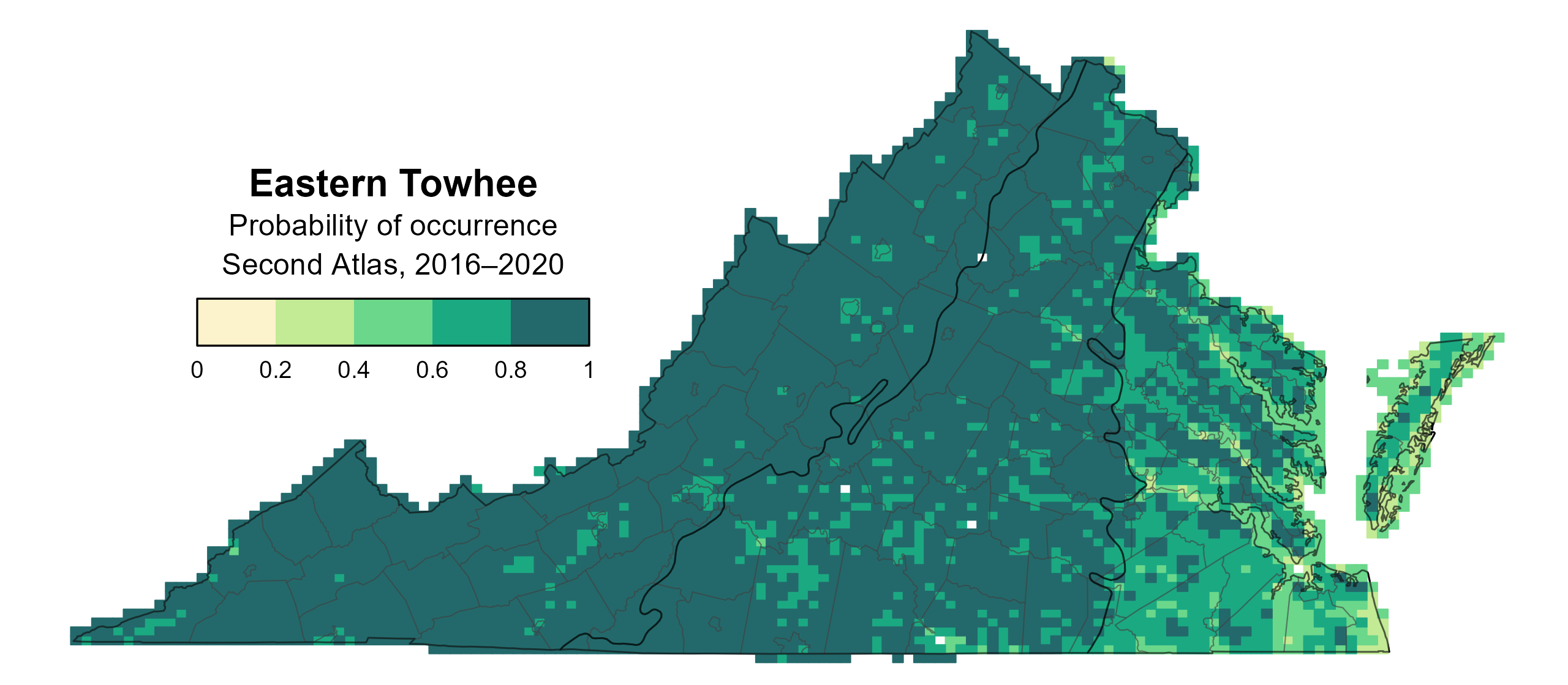
Figure 1: Eastern Towhee breeding distribution based on probability of occurrence (Second Atlas, 2016–2020). This map indicates the probability that this species will occur in an Atlas block (an approximately 10 mi2 [26 km2] survey unit) based on environmental (including habitat) factors and after adjusting for the probability of detection (variation in survey effort among blocks).
Breeding Evidence
Easter Towhees were confirmed breeders in 373 blocks and 89 counties and probable breeders in an additional 27 counties (Figure 2). Eastern Towhee breeding observations were recorded in all regions of the state during the First Atlas as well (Figure 3).
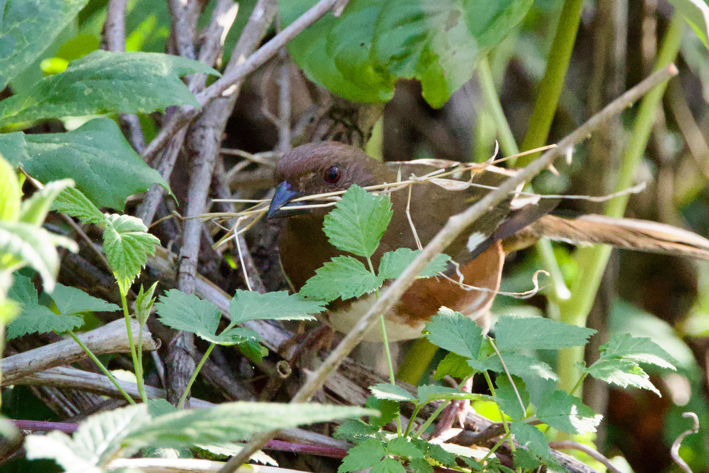
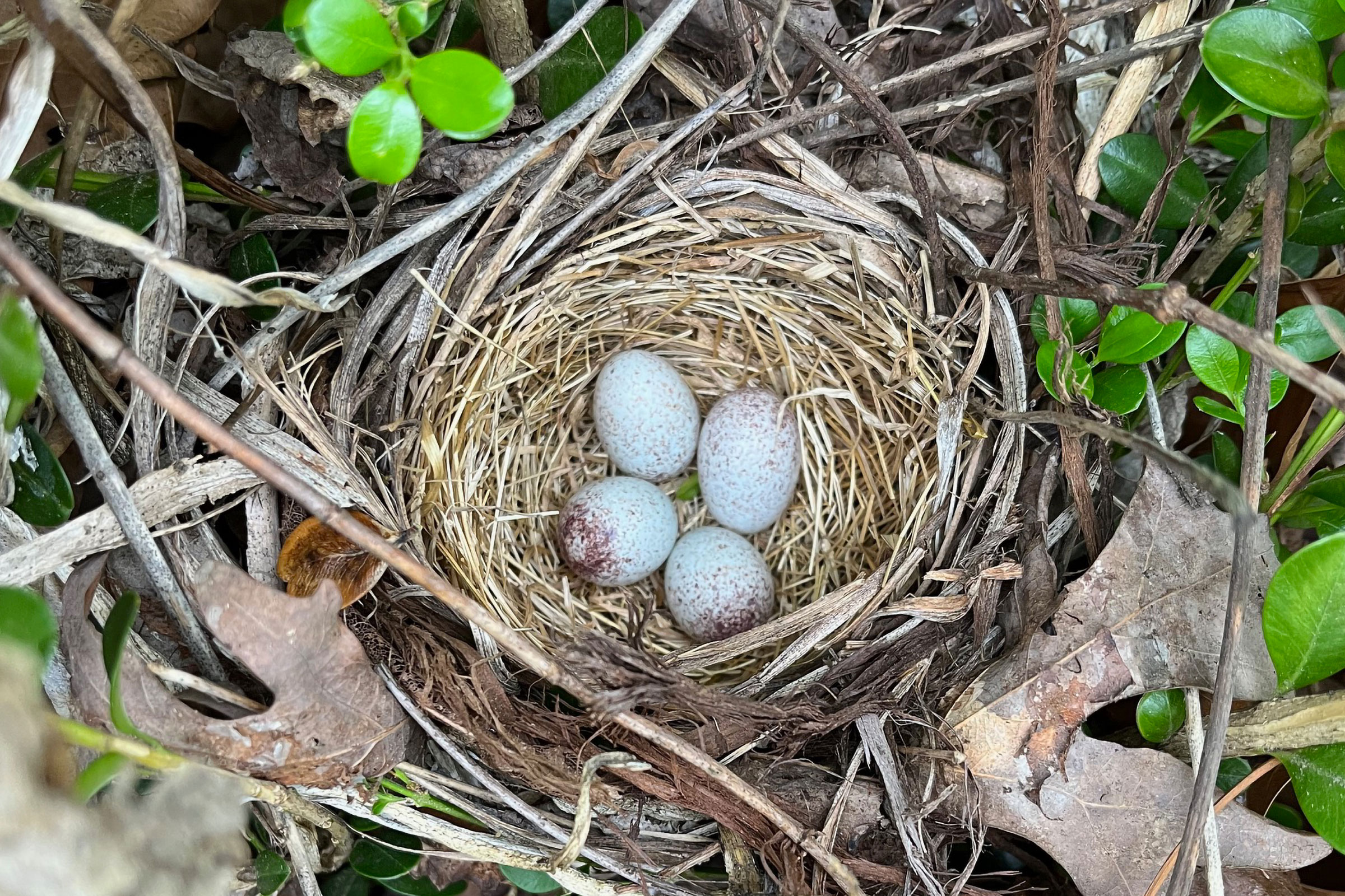
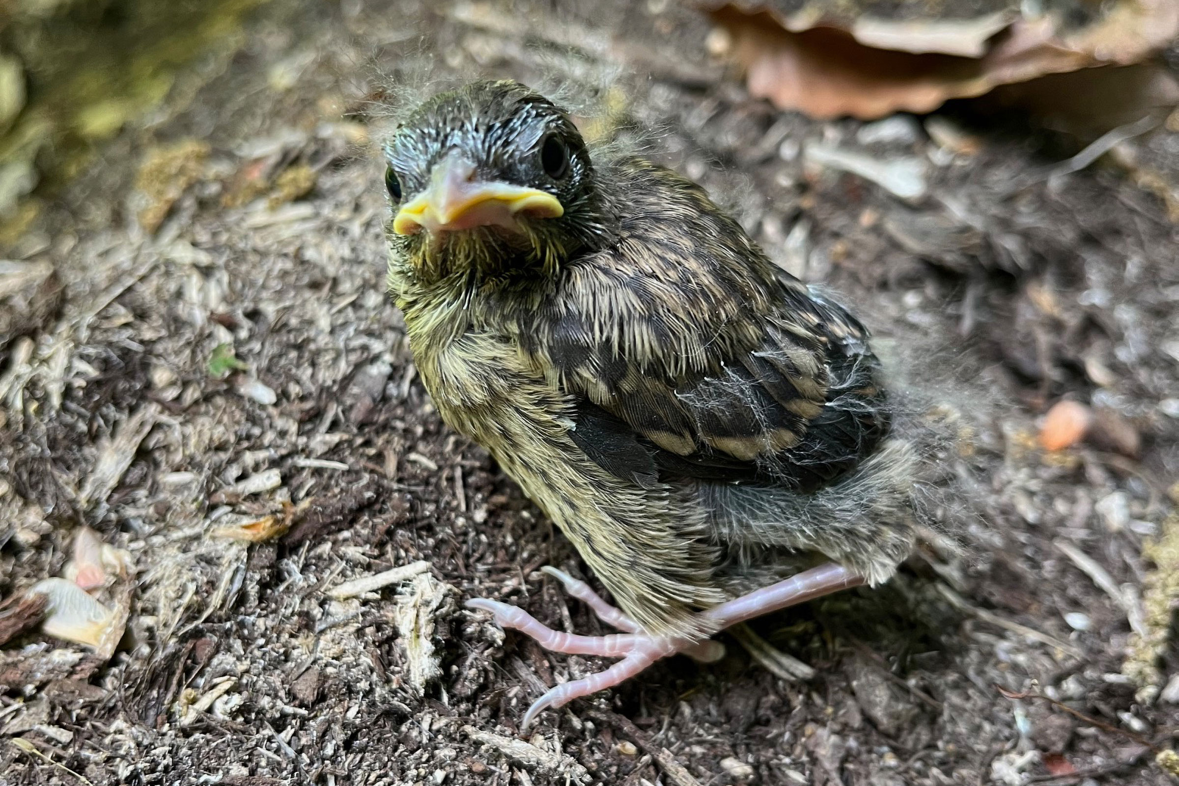
Birds were seen carrying nesting material as early as April 15 and carrying food from April 27 (Figure 4). Towhees continued feeding young through the end of August, with exceptionally late fledglings seen on September 15.
For more general information on the breeding habits of the Eastern Towhee, please refer to All About Birds.
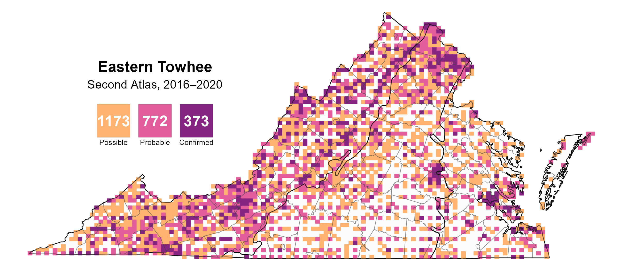
Figure 2: Eastern Towhee breeding observations from the Second Atlas (2016–2020). The colored boxes illustrate Atlas blocks (approximately 10 mi2 [26 km2] survey units) where the species was detected. The colors show the highest breeding category recorded in a block. The numbers within the colors in the legend correspond to the number of blocks with that breeding evidence category.
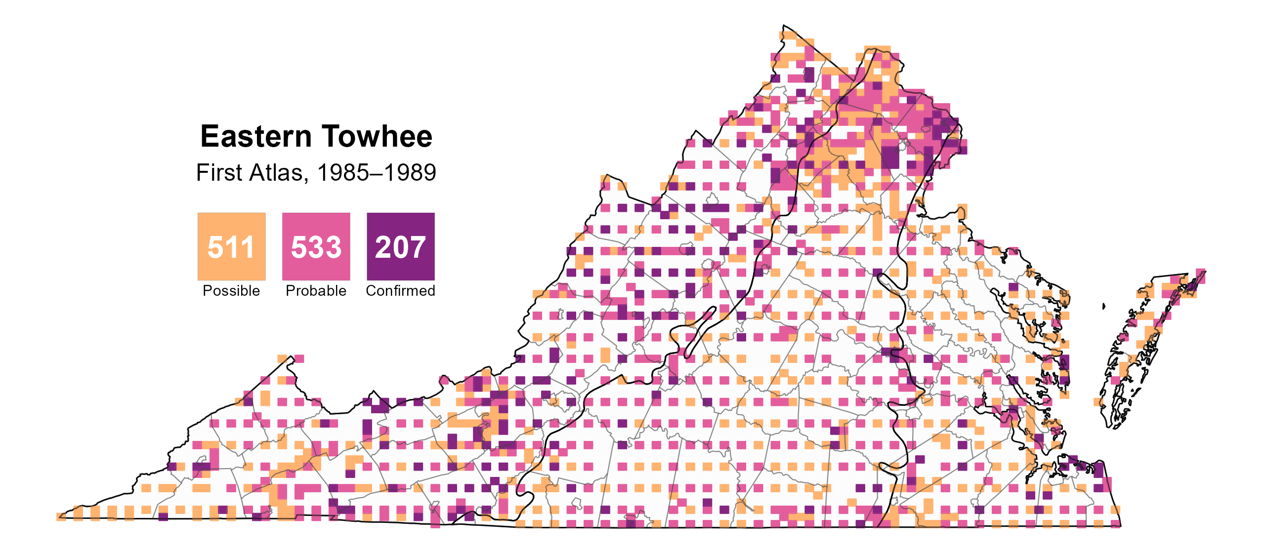
Figure 3: Eastern Towhee breeding observations from the First Atlas (1985–1989). The colored boxes illustrate Atlas blocks (approximately 10 mi2 [26 km2] survey units) where the species was detected. The colors show the highest breeding category recorded in a block. The numbers within the colors in the legend correspond to the number of blocks with that breeding evidence category.
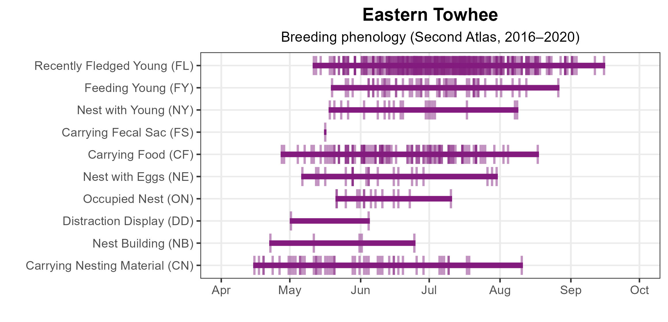
Figure 4: Eastern Towhee phenology: confirmed breeding codes. This graph shows a timeline of confirmed breeding behaviors. Tick marks represent individual observations of the behavior.
Population Status
Eastern Towhee relative abundance was estimated to be highest throughout the Mountains and Valleys region, especially in the more northwestern portion, moderate in the Piedmont region, and lowest in the Coastal Plain region (Figure 4).
The total estimated Eastern Towhee population in the state is approximately 928,000 individuals (with a range between 770,000 and 1,121,000). The North American Breeding Bird Survey (BBS) showed that the Eastern Towhee’s population experienced a significant decrease of 2.01% per year from 1966–2022 (Hostetler et al. 2023; Figure 5), with the steepest declines during the early period of the BBS. Between the First and Second Atlas, BBS data showed no strong trend, with a nonsignificant decline of 0.52% per year from 1987–2018.

Figure 5: Eastern Towhee relative abundance (Second Atlas, 2016–2020). This map indicates the predicted abundance of this species at a 0.4 mi2 (1 km2) scale based on environmental (including habitat) factors. Abundance values are presented on a relative scale of low to high.
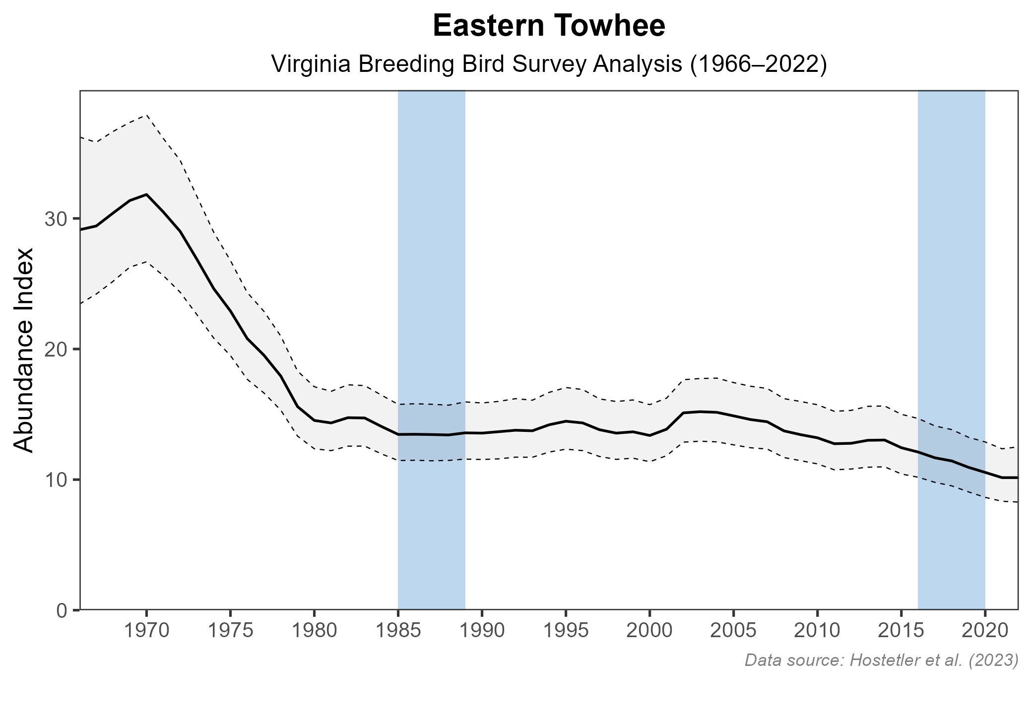
Figure 6: Eastern Towhee population trend for Virginia as estimated by the North American Breeding Bird Survey. The vertical axis shows species abundance; the horizontal axis shows the year. The solid line indicates the estimated population trend; there is a 97.5% probability that the true population trend falls between the dashed lines. The shaded bars indicate the First and Second Atlas periods.
Conservation
The Eastern Towhee experienced a substantial decline from the 1960s to the 1980s and is still in decline today (Rottenborn and Brinkley 2007). As such, the 2025 Virginia Wildlife Action Plan includes this species as a Tier IV Species of Greatest Conservation Need, indicating that long-term plans are needed to prevent further losses (VDWR 2025).
The Eastern Towhee’s reliance on forest succession makes it sensitive to human land-use changes; thus, maintaining mid-successional habitat and forest diversity through forest harvest would be beneficial for the species (Greenlaw 2020).
Interactive Map
The interactive map contains up to six Atlas layers (probability of occurrence for the First and Second Atlases, change in probability of occurrence between Atlases, breeding evidence for the First and Second Atlases, and abundance for the Second Atlas) that can be viewed one at a time. To view an Atlas map layer, mouse over the layer box in the upper left. County lines and physiographic regional boundaries (Mountains and Valleys, Piedmont, and Coastal Plain) can be turned on and off by checking or unchecking the box below the layer box. Within the map window, users can hover on a block to see its value for each layer and pan and zoom to see roads, towns, and other features of interest that are visible beneath a selected layer.
View Interactive Map in Full Screen
References
Greenlaw, J. S. (2020). Eastern Towhee (Pipilo erythrophthalmus), version 1.0. In Birds of the World (P. G. Rodewald, Editor). Cornell Lab of Ornithology, Ithaca, NY, USA. https://doi.org/10.2173/bow.eastow.01.
Hostetler, J. A., J. R. Sauer, J. E. Hines, D. Ziolkowski, and M. Lutmerding (2023). The North American breeding bird survey, analysis results 1966–2022. U.S. Geological Survey, Laurel, MD, USA. https://doi.org/10.5066/P9SC7T11.
Rottenborn, S. C., and E. S. Brinkley (Editors) (2007). Virginia’s birdlife: an annotated checklist. 4th edition. Virginia Society of Ornithology.
Virginia Department of Wildlife Resources (VDWR). 2025. Virginia wildlife action plan. Virginia Department of Wildlife Resources, Henrico, VA, USA. 506 pp.